Federated Marine SDI 2023
For more information please contact innovation@ogc.org
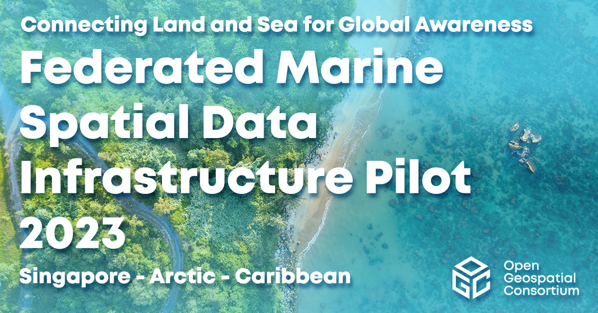
Federated Marine Spatial Data Infrastructure (FMSDI) Pilot 2023 – Connecting Land and Sea for Global Awareness
Introduction
Climate change, marine pollution, and population growth are affecting the world’s coasts, the most critical area of life for billions of people. Habitats are lost, sea levels are rising, and microplastics continue to increase and enter local food chains. How can environmental change be measured in concrete terms? What is the rate of change that affects dependent populations and ecosystems? What are the effects of possible countermeasures?
The OGC Federated Marine Spatial Data Infrastructure Pilot (FMSDI 2023) had tasked itself with researching the reliable data available in this area and how it could be efficiently integrated into workflows for analyzing the effects of climate change on our coastal areas. The aim was to create an efficient data and service landscape to support stakeholders and decision-makers in the changing coastal environment.
Challenges
One of the biggest challenges of this work is integrating data from the sea with data from the land into a common system – in other words, overcoming the discrepancy between marine and terrestrial data systems and the definition of a digital twin to represent the coastal environment. Such a twin enables those responsible for better evaluating and visualizing the effects on the environment, leading to quicker decisions on protecting coastal areas and their inhabitants.
Another big challenge is developing an improved methodology for detecting and integrating geodata on land and sea to support analysis services from various sources. Also, the concept of a multi-dimensional Information model that combines the spatial extent (x, y) with vertical dimensions (z), temporal dimensions (t), flow vectors (v), and the life cycle management of the scientific research (s). These dimensions are designed to provide predictive insights into the temporal changes in a fluid Arctic environment that climate change affects.
Using and integrating charting and navigation data in different application scenarios are also challenging for Hydrographic Offices worldwide. Inconsistency in existing feature types from one region to another, lack of access to the original charting data, and data misalignment between land and sea are a few examples of the challenges.
The project summarizes results from three coastal regions that are particularly affected by the consequences of climate change: the Canadian Arctic, the Caribbean islands, and the Republic of Singapore:
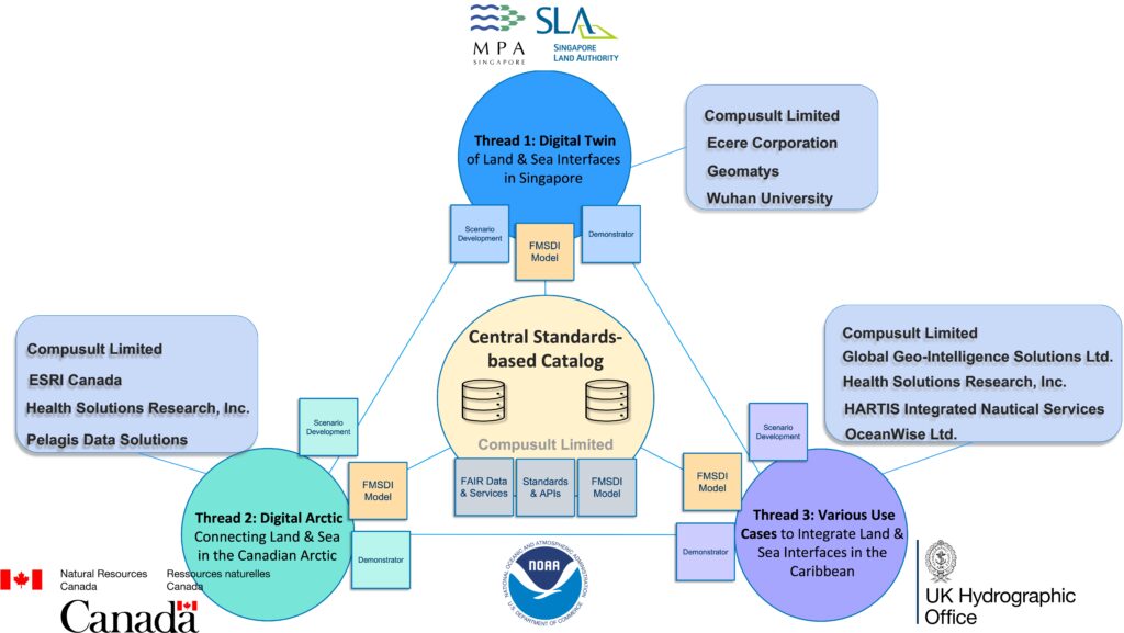
Technical Architecture of the FMSDI Pilot 2023 (three threads and their cross relationships)
Thread 1: Digital Twin of Land and Sea Interfaces – Singapore
Since around 30% of Singapore’s land mass is less than 5 meters above sea level, the seamless integration of land and marine data is essential to Singapore’s focus on coastal protection and climate resilience. Different authorities are responsible for the data, which makes it challenging to work across organizations. This part looks at the geo-integration requirements through the development of a multi-dimensional digital twin of Singapore’s coastline.
Thread 2: Digital Arctic Connecting Land and Sea – Canada
This part deals with geodata discovery and integration challenges concerning the Canadian Arctic. The loss of sea ice, the progressive warming of the oceans, stronger winds and currents, and the accelerated erosion of coastlines are affecting Arctic communities. Therefore, efficient data utilization and analysis are of utmost importance for Canada.
Thread 3: Integrating Land & Sea for Various Use Cases – Caribbean.
This part investigates how data developed primarily for navigation at sea can be used in other contexts. Can they also be used to build local capacity in the Caribbean and better understand the application of marine data in extended sea-land contexts?
The OGC Federated Marine Spatial Data Infrastructure Pilot 2023 will be conducted under OGC’s Collaborative Solutions and Innovation (COSI) Program. To learn about the benefits of sponsoring an OGC COSI Program Initiative such as this, visit the OGC COSI Program webpage.
Results
From a technical point of view, the pilot has once again proven the performance of OGC API interface standards as well as OGC Catalogue Service Standard. Furthermore, it has shown how scale an multidimentionality could be addressed using GeoDataCubes. It also highlighted the existing and still unresolved challenges in connecting the land and sea data.
The Engineering Report for FMSDI Pilot 2023 will soon be published, but the YouTube playlist is already available. The FMSDI 2023 pilot also features a series of persistent demonstrators as one of its outputs. These demonstrators showcase how geospatial data can be used in an operational context or highlight the gaps in online resources, including data sources, metadata, access processes, and standards.
It should be noted that FMSDI Pilot 2023 initiative builds on the result of the OGC FMSDI Pilot Phases one, two, and three, which ran from September 2021 to January 2023. These pilots built on the works of prior OGC COSI Program initiatives, such as the Marine Spatial Data Infrastructure Concept Development Study, the Maritime Limits and Boundaries Pilot, and the Arctic Spatial Data Pilot.
| Maritime and Port Authority of Singapore (MPA) | |
| Natural Resources Canada (NRCan) | |
| National Oceanic and Atmospheric Administration (NOAA) |  |
| Singapore Land Authority (SLA) |  |
| UK Hydrographic Office (UKHO) |  |
Sponsoring Organizations
The following OGC Member organizations sponsored the OGC FMSDI Pilot 2023. The sponsors provide interoperability requirements, cost-share funding, and geospatial data required to run the scenarios.
Call for Sponsors
Given the multi-phased approach of this pilot, it is still possible to join the future pilot as a sponsoring organization. To learn more about the benefits of sponsoring an OGC COSI Program Initiative such as this, visit the OGC COSI Program webpage. If you are interested in sponsoring the pilot, please contact innovation@ogc.org for more information.
Participants
| Compusult |  | Ecere |  |
| ESRI Canada | Geomatys |  | |
| GGIS |  | HARTIS |  |
| HSR |  | OceanWise |  |
| Pelagis | Wuhan University |  |
Persistent Demonstrators
The persistent demonstrators are workflows and applications that stakeholders can access for outreach, testing, and experimentation purposes. They are referred to as persistent because they remain available even after the project is completed, but only until December 2024. As each participant has their own solution platform, they have taken different approaches, all of which are available for review by stakeholders. Security concerns, such as authentication and authorization, are unique to each participant and have been communicated to stakeholders and participant contacts. For further details and access to the demonstrators, please refer to the link provided.
Thread 1 Singapore
Compusult
URL(s) to Persistent Demonstrator: https://ogc.compusult.com/singapore
Login with:
Please email fmsdi2023@gmail.com for access credentials.
Ecere
URL(s) to Persistent Demonstrator: https://maps.gnosis.earth/fmsdi4/
Login with:
Please email fmsdi2023@gmail.com for access credentials.
Geomatys
3D Visualization client is developed with Unreal Engine. The Demonstrator is a desktop client and you have to download the executable before use.
Please download from the following URL: https://fmsdi.geomatys.com
Login with:
Please email fmsdi2023@gmail.com for access credentials.
Requirements:
- Microsoft Windows operating system version 10/11.
- high-performance GPU & CPU.
- Visual C++ redist : https://aka.ms/vs/17/release/vc_redist.x64.exe
- DirectX : https://aka.ms/dxsetup
WHU
URL(s) to Persistent Demonstrator: http://oge.whu.edu.cn/singapore
Login with:
Please email fmsdi2023@gmail.com for access credentials.
Thread 2 Arctic
Compusult
URL(s) to Persistent Demonstrator: https://ogc.compusult.com
Login with:
Email: ogc-arctic@compusult.com
Password: VBbc9w2vy7XK!
ESRI Canada
Esri Canada’s FMSDI Digital Arctic Project demonstration site illustrates a climate change impact scenario in the Canadian Arctic region. This initiative encompasses the creation of a bilingual data catalog portal and a collection of web maps sourced from various web services. These maps include base maps, climate change maps, impact maps, and specialized thematic maps.
URL(s) to Persistent Demonstrator: https://esrica-ncr.maps.arcgis.com/home/group.html?id=5c69123818b94b4ebf85370a75e6b404#overview
Health Solutions Research
Persistent demonstrator of the Plastic Bioaccumulation Health Risk Index
Open GeoMD Platform: https://opengeomd.hsrhealthanalytics.org/
- Containing all Canadian Arctic layers: https://opengeomd.hsrhealthanalytics.org/catalogue/#/map/63
- Census Subdivision layer: https://opengeomd.hsrhealthanalytics.org/catalogue/#/dataset/65
- Rasterized layer: https://opengeomd.hsrhealthanalytics.org/catalogue/#/dataset/50
- Plastic Presence layer: https://opengeomd.hsrhealthanalytics.org/catalogue/#/dataset/64
OGC API Endpoint for the Open GeoMD Platform: http://opengeomdapi.hsrhealthanalytics.org/
Pelagis
Digital Earth – Arctic This environment is hosted to the IEEE GRSS evaluation sandbox located here. Security credentials must be provided specific to each user. Contact glennlaughlin@pelagis.io for site access.
Satellite-derived Sea Ice Observations The sea ice observations based on the NSIDC EarthData services is available through a library of Jupyter notebooks and utilities. The library will be posted to the OGC Marine Github repository in support of work associated with the OGC Marine Conceptual Model efforts. Please note that access to the NSIDC portal requires specific authentication which must be registered for each end user.
Thread 3 Caribbean
Compusult
URL(s) to Persistent Demonstrator: https://ogc.compusult.com
Login with:
Email: ogc-caribbean@compusult.com
Password: 1En88LuSmUFa!
Global Geo-Intelligence Solutions (GGIS)
The Persistent Demonstrator provides a view of the final storm surge risk map over a base map along with the hurricane path. OGC API Features was utilized to enable data sharing.
URL(s) to Persistent Demonstrator:
- Anguilla: https://foresightcarbon.com/reports-drm/index.html#67-91
- The Bahamas: https://foresightcarbon.com/reports-drm/index.html#68-89
- The Commonwealth of Dominica: https://foresightcarbon.com/reports-drm/index.html#69-100
HARTIS Integrated Nautical Services
A story map which provides a high-level outline of the project has been created and it is available through a Persistent Demonstrator
URL(s) to OWF-DSS Persistent Demonstrator:
https://fmsdi.hartis.org/
Health Solutions Research
Persistent Demonstrator of the Hurricane Health Risk Index
URL(s) to Persistent Demonstrator:
- Anguilla – https://opengeomd.hsrhealthanalytics.org/catalogue/#/dataset/23
- Bahamas – https://opengeomd.hsrhealthanalytics.org/catalogue/#/dataset/24
- The Commonwealth of Dominica – https://opengeomd.hsrhealthanalytics.org/catalogue/#/dataset/40
- Map of all 3 – https://opengeomd.hsrhealthanalytics.org/catalogue/#/map/60
- OGC API Instance – http://opengeomdapi.hsrhealthanalytics.org/
OceanWise
Web Mapping DemonstratorURL(s) to Persistent Demonstrator is still pending License agreements between UKHO and OGC.